
In April 2016, Mayor Megan Barry announced a new program to improve mobility and safety for all modes of transportation. The new program features ongoing improvements to intersections throughout Davidson County.
Press Release: Mayor Barry Announces New Program to Improve Key Intersections
Project Updates
July 11, 2016 Progress / Status Update
Intersection Improvement Descriptions
Abbott Martin Road at Estes Road, Harding Place at Estes Road, and Hobbs Road at Estes Road
These 3 intersections encompass a busy corridor along Estes Road that each service over 15,000 vehicles a day. There has been growing concern with the safety of motorists and pedestrians at these intersections with narrow roads and limited pedestrian facilities in this residential area. Correspondingly, there have been a number of vehicular accidents that have resulted in personal injuries and property damage at each intersection. Keeping these concerns in mind, the intersection program will create safer facilities for all modes of transportation. Traffic signals will also be replaced and retimed for the entire corridor to coordinate better traffic flow and movements while reducing the average wait time for the area’s residents for current and future traffic. Improvements:
- Replace signals and coordinate signal timing for the entire corridor
- New sidewalks and pedestrian signals, New additional turn lanes
- New curb ramps and cross walks
- Repave and restripe entire intersections
Battery Lane at Granny White Pike
The intersection is located near Lipscomb Academy just north of Radnor Lake. With average daily traffic of nearly 22,000 vehicles, it is one of the busier and more congested intersections in Nashville. It has had multiple wrecks over the past three years that have resulted in property damage and even injury. Having residences and a school near this high volume intersection has also led to a concern for pedestrians in the area. We plan to implement multiple improvements for this intersection to improve safety and function. Improvements:
- Replace signals and coordinate signal timing for the entire corridor
- New sidewalks and pedestrian signals
- New curb ramps and cross walks, New additional turn lanes
- Repave and restripe entire intersections
- New concrete island in southwest corner
Bell Road at Mt. View Road
Peak traffic hours are often congested by a limited amount of space for left turning vehicles at this intersection. In addition, the pedestrian facilities at the intersection do not provide adequate comfort and safety for the many pedestrians traversing it. We plan to extend the sidewalk on Bell Road and provide new pedestrian signals improve safety for foot-travelers. Plans also include improvements to signal timing to maximize the efficiency of the intersection and reduce commute time for the areas residents. Improvements:
- Remove concrete median on Mt. View Road and add a second left turn lane.
- New concrete refuge island in south west corner of intersection
- New pedestrian signals with protected pedestrian crossings
- Sidewalk extension and improvements with curb ramps
Dr. D.B. Todd Jr. Boulevard at Albion Street
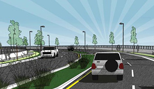
Nearly 12,000 vehicles travel Dr. D.B. Todd Jr. Boulevard each day, and recent counts place an average of 250-300 people walking during peak commute hours at the nearby intersection of Jefferson Street and D.B. Todd Jr. Boulevard. MTA’s #19 Herman route also travels this intersection, carrying approximately 28,000 riders per month. Rapid-transit infrastructure and service is also proposed for this location in both Scenario 1 of MTA’s nMotion mass transit strategic planning study and the Northwest Corridor Transit Study. Over the last 3 years, the intersection has seen crashes resulting in either injuries or property damage. We will update traffic-signal technology, with new ornamental poles reflecting the historical context of nearby Meharry Medical College and Fisk University. Repaving, new signal timing, and turn lanes will help to relieve auto congestion, and pedestrian safety will be enhanced with new crosswalks, curb ramps, and countdown signals.
Dr. D.B. Todd Jr. Boulevard Perspective
Gallatin Pike at Shepherd Hills Drive
The intersection of Gallatin Pike and Shepherd Hills Drive is a busy one, catering to many pedestrians and frequenters of the RiverGate Mall as well as servicing over 38,000 vehicles a day. Sidewalks, crosswalks, and adequate lighting provide poor conditions to service the necessary foot traffic in the area, which has unfortunately resulted in a past casualty. With the aid of the newly implemented intersection improvement program, this intersection will be updated with the necessary safety features. New sidewalks, shared use paths, and pedestrian signals will add comfort to pedestrians traveling to and from the Rivergate Mall. Adjusted signal timings, new lighting, and new pavement markings will improve the functionality and safety of the intersection as well. Improvements:
- Install sidewalk and shared use path for pedestrians and cyclists
- Revise signal timing to improve efficiency
- Install new pedestrian signals with new crosswalks and ramps
- Install sidewalk and crosswalks to Rivergate Drive
- Relocate bus stop and shelter and install lighting for the entire intersection
- Repave and restripe entire intersection
Gallatin Pike at West Eastland Avenue
East Nashville is a quickly developing area, and the intersection of Gallatin Pike and West Eastland Avenue is no exception. Currently, both roads combine to service over 31,000 vehicles a day in that area. The current volume and intersection geometry has caused numerous accidents and troublesome congestion for east Nashville’s residents and businesses. The heavy pedestrian traffic further impairs vehicular traffic. Currently, Nashville Department of Transportation and the Tennessee Department of Transportation are teaming up to provide a solution for this problem intersection.
Hobson Pike at Pin Hook Road
The intersection of Hobson Pike and Pin Hook Road is located in a residential neighborhood in the vicinity of Antioch High School and John F. Kennedy Middle School, a walking community priority area. Hobson Pike services over 10,000 vehicles each day, leading to delays and heavy traffic congestion during school opening and closing hours. There is also a history of crashes at this intersection. Hobson Pike is also a designated bike route and the project will be coordinated with WalknBike, the Metro Bike and Sidewalk Strategic Plan, to improve conditions for all modes of transportation. Improvements:
- Revise signal timing to improve efficiency
- Improve current facilities for a safer bike route
- Install turn lanes
- Repave and restripe entire intersection
Moormans Arm Road at Whites Creek Pike
Over 10,000 vehicles travel Whites Creek Pike and nearly 6,000 vehicles travel Moormans Arm Road each day. Over the last 3 years, the intersection has seen crashes resulting in either injuries or property damage. The MTA #14 Whites Creek route runs along Whites Creek Pike and an existing bus stop is located just north of the intersection. This creates a potential for heavy pedestrian traffic in this area, particularly with the entrance to Haynes Garden Apartments being located here. There are minimal shoulders along Moormans Arm Road and very little shoulder area along Whites Creek Pike. We will provide pedestrian enhancements including sidewalks, crosswalks, curb ramps, and updating of pedestrian signals. Improvements:
- Revise signal timing to improve efficiency
- New sidewalk and pedestrian signals
- New curb ramps and cross walks, New additional turn lanes
- Repave and restripe entire intersection
- Improve bus stop/shelter
Neelys Bend Road at Cheyenne Boulevard
Nearly 10,000 vehicles travel Neelys Bend Road daily, and around 8,000 transit customers ride MTA’s #76 Madison Connector (which services Neelys Bend) each month. Over the last 3 years, the intersection of Neelys Bend Road and Cheyenne Boulevard has seen crashes resulting in either injuries or property damage. Traffic congestion around Neelys Bend Elementary and Middle Schools is heaviest during the morning commute and is expected to worsen with anticipated new growth in the area. We plan to extend turn lanes on Neelys Bend Road, install a new traffic signal, and improve the walk to school for children and caregivers in the surrounding community by applying new pedestrian curb ramps at each corner. An additional proposed improvement includes realigning Neelys Bend Circle with Neelys Bend Road.
Neelys Bend Road at Randy Road
Neelys Bend Road has nearly 10,000 vehicles traveling it daily. Additionally, approximately 8,000 local residents and attendants of the nearby Smithson-Craighead Academy ride MTA’s #76 Madison Connector each month. The intersection of Neelys Bend Road and Randy Road has seen crashes over the last 3 years resulting in either injuries or property damage. With a safety oriented approach by the newly implemented Intersection Program, we plan to add pedestrian signals, sidewalks, curb ramps, and crosswalks at the intersection. Additionally, a traffic analysis will be performed to determine the potential need for a south bound center turn lane on Randy Road and a west bound right turn lane on Neelys Bend Road. Consideration of traffic flows from Florence Circle, as well as other signals on the Neelys Bend corridor, will be used in evaluating the design of the Neelys Bend Road and Randy Road intersection to alleviate future projected congestion. Coordination with Metro Transit Authority will also determine the potential addition of a bus stop for this project as well. Intersection Improvement Project:
- Revise signal timing to improve efficiency
- New extended sidewalk and pedestrian signals
- New curb ramps and cross walks
- Repave and restripe entire intersection
- Analyze need for turn lanes
Wallace Road at Recovery Road and Brookridge Trail
Currently, the intersections are experiencing pedestrian and vehicular challenges. These intersections create conflict that pose a danger to over 6000 daily motorists and local residents. Nashville Department of Transportation, under the new intersection improvement program, is embarking on plans to improve pedestrian mobility and safety, and reduce traffic accidents. New signage and striping will create an all-way stop to allow a more effective flow of traffic. In addition to the repaving of the intersection area, new pedestrian infrastructure will be installed which will enhance pedestrian safety. These new features, along with existing bicycle and bus infrastructure, will improve the multimodal opportunities for the area. Improvements:
- New stop signs and pavement markings
- New pedestrian crossings and updated sidewalks
- Improved bike and bus facilities
- Curb ramps with detectable warnings
- Resurfacing